Data
169,660 items of data are available, covering 159,517 participants, encoded using Data-Coding
4.
Defined-instances run from 0 to 1, labelled using Instancing
1.
2 Instances
Instance 0 : Baseline (1998-2004)
159,517 participants, 159,517 items
Instance 1 : Resurvey (2015-2019)
10,143 participants, 10,143 items
Notes
AGEM = Area Geographica Estadistica Municipal
1 The National Geostatistical Framework (El Marco Geoestadistico Nacional) is a national system designed by the INEGI (Instituto Nacional de Estadistica, Geografia e Informatica) to reference the statistical information of censuses and surveys with the corresponding geographical location. Geostatistical boundaries are conventional dividing lines which delimit the national territory in to geostatistical areas which adhere, as far as possible, to political-administrative boundaries.
The levels of disaggregation are: state (Areas geoestadisticas estatales=AGEE), municipal (Areas geoestadisticas municipales=AGEM) and basic (Areas geoestadisticas basicas=AGEB).
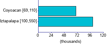
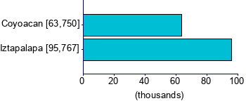
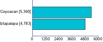
The MCPS recruited participants from two neighbouring districts - Coyoacan (AGEM=3) and Iztapalapa (AGEM=7).
1. https://www.inegi.org.mx/app/glosario/default.html?p=MCS2015 (accessed 1st May 2025)
0 Related Data-Fields
There are no related data-fields
0 Resources
There are no matching Resources